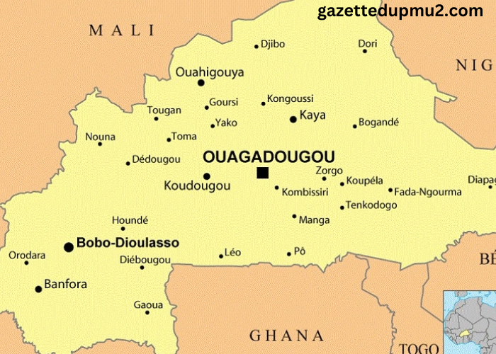
Understanding the geographical layout of Burkina Faso is essential for anyone interested in the country, whether for travel, research, or business purposes. The Carte du Burkina Faso, or map of Burkina Faso, provides a detailed view of the country’s topography, regions, and key landmarks. This article offers an in-depth exploration of the Carte du Burkina Faso, highlighting its importance and how it can be utilized to gain a better understanding of this West African nation.
Introduction to Burkina Faso
Burkina Faso is a landlocked country situated in West Africa. It is bordered by six countries: Mali to the northwest, Niger to the east, Benin to the southeast, Togo and Ghana to the south, and Ivory Coast to the southwest. With its diverse landscapes and cultural heritage, Burkina Faso offers a rich tapestry of experiences for those who delve into its geography.
Overview of the Carte du Burkina Faso
Geographic Scope
The Carte du Burkina Faso encompasses the entire country, providing a comprehensive overview of its physical features and administrative divisions. The map showcases the varied terrain of Burkina Faso, which includes savannahs, plateaus, and river valleys. This geographic diversity influences the climate, vegetation, and human activities within the country.
Key Features and Elements
A typical Carte du Burkina Faso includes several key features:
- Regions and Provinces: Burkina Faso is divided into several regions, each with its own administrative and cultural significance. The map highlights these regions, along with their respective provinces and major cities. This division is crucial for understanding the political and administrative organization of the country.
- Topographical Details: The map provides insights into the country’s topography, including mountain ranges, plateaus, and river systems. Notable geographical features include the Sahel region to the north and the Sudanian Savanna to the south. The map also details significant rivers such as the Niger and Volta rivers, which are vital for agriculture and transportation.
- Major Cities and Landmarks: The Carte du Burkina Faso marks key cities such as Ouagadougou (the capital), Bobo-Dioulasso, and Koudougou. It also highlights important landmarks, including historical sites, national parks, and cultural centers. These locations are essential for understanding the country’s heritage and tourism potential.
- Transportation Networks: The map includes information on transportation infrastructure, including major roads, railways, and airports. This is valuable for planning travel and understanding the connectivity within the country.
Importance of the Carte du Burkina Faso
Navigational Aid
The Carte du Burkina Faso is an essential tool for navigation and orientation within the country. For travelers, it provides a clear picture of the country’s layout, helping them plan routes and reach their destinations efficiently. Whether navigating the bustling streets of Ouagadougou or exploring remote rural areas, the map is a valuable resource.
Educational Resource
For researchers, students, and academics, the Carte du Burkina Faso serves as an educational resource for studying the country’s geography. It aids in understanding the spatial distribution of resources, population centers, and environmental features. The map is also useful for analyzing regional development and planning.
Business and Development Planning
Businesses and development organizations use the Carte du Burkina Faso for strategic planning and decision-making. The map helps in identifying potential markets, assessing infrastructure needs, and planning investment projects. Understanding regional characteristics and connectivity is crucial for effective business operations and development initiatives.
Cultural and Historical Insights
The Carte du Burkina Faso provides cultural and historical insights by highlighting important landmarks and historical sites. It helps in appreciating the country’s heritage, including ancient ruins, traditional settlements, and cultural festivals. The map serves as a guide for those interested in exploring Burkina Faso’s rich history and cultural diversity.
Utilizing the Carte du Burkina Faso
Planning Travel
For tourists and travelers, the Carte du Burkina Faso is a practical tool for planning trips. It enables them to identify key destinations, such as national parks, wildlife reserves, and cultural attractions. By understanding the map, travelers can plan their itineraries, choose appropriate transportation routes, and explore various regions of the country.
Conducting Research
Researchers studying Burkina Faso’s geography, environment, or socio-economic conditions can benefit from the Carte du Burkina Faso. The map provides essential data for geographical studies, environmental assessments, and socio-economic analyses. It helps researchers visualize spatial relationships and make informed conclusions.
Supporting Humanitarian Efforts
Humanitarian organizations use the Carte du Burkina Faso to support their initiatives and provide aid. The map assists in identifying areas in need of assistance, planning relief operations, and coordinating with local authorities. It is a vital resource for effective humanitarian intervention and support.
Enhancing Regional Awareness
For residents and expatriates, the Carte du Burkina Faso enhances regional awareness and understanding. It helps them navigate their surroundings, learn about neighboring regions, and connect with local communities. The map fosters a deeper appreciation of Burkina Faso’s geographic and cultural diversity.
Challenges and Considerations
Map Accuracy and Updates
One challenge with maps, including the Carte du Burkina Faso, is ensuring accuracy and up-to-date information. Geographic and administrative changes can affect map details, so it is essential to use the most current version of the map. Regular updates and revisions help maintain accuracy and relevance.
Cultural Sensitivity
When utilizing the Carte du Burkina Faso for various purposes, it is important to approach it with cultural sensitivity. Understanding the cultural and social context of different regions enhances the effectiveness of planning, research, and engagement activities. Respect for local customs and traditions is crucial for successful interactions.
Integration with Technology
The integration of traditional maps with modern technology, such as Geographic Information Systems (GIS) and digital mapping tools, can enhance the usability of the Carte du Burkina Faso. Digital maps provide interactive features, real-time updates, and advanced analytical capabilities, offering a more comprehensive view of the country.
Conclusion
The Carte du Burkina Faso is a valuable resource for understanding the country’s geography, administrative divisions, and key features. It serves as an essential tool for navigation, education, business planning, and cultural exploration. By providing detailed insights into Burkina Faso’s physical and cultural landscape, the map enhances our ability to engage with and appreciate this West African nation.
Utilizing the Carte du Burkina Faso effectively involves understanding its key features, addressing challenges related to accuracy and cultural sensitivity, and integrating it with modern technological tools. Whether for travel, research, or development, the map offers crucial information for a comprehensive understanding of Burkina Faso’s diverse geography and rich heritage.


